


Shipping Lanes: Complete World Map and Route Guide
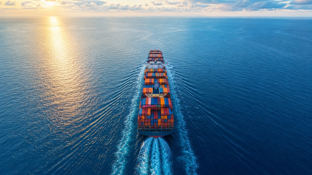
Shipping lanes are the regularly traveled sea routes that most vessels follow across the world's oceans. Think of them as highways at sea: instead of ships scattering randomly across millions of square miles of water, traffic clusters into predictable corridors connecting the world's major ports. These routes are shaped by geography, trade demand, international regulation, and centuries of maritime experience.
Roughly 80-90% of global trade by volume moves by sea, and nearly a third of it funnels through a small number of narrow chokepoints. Understanding where those lanes run, why they exist, and what happens when they get blocked helps explain why a ship grounding in Egypt or an attack in the Red Sea can ripple into shortages on shop shelves thousands of miles away.
This guide covers the world's major shipping lanes, the chokepoints that make them vulnerable, and how to follow real vessels crossing those routes in real time.
What Are Shipping Lanes?
Shipping lanes are not painted on the ocean floor. They emerge from a combination of physics, regulation, and economics. Ships follow these corridors because they represent the safest and most efficient paths between ports, not because someone assigned them a numbered berth.
At the most formal level, certain narrow or heavily trafficked areas use Traffic Separation Schemes (TSS): officially designated one-way corridors with buffer zones between opposing flows, approved by the International Maritime Organization. The IMO is the UN agency that sets global standards for maritime safety and adopts TSS frameworks in congested areas like the English Channel, the Strait of Malacca, and the Suez Canal approaches.
Outside formal schemes, the open ocean has no painted lines. Ships cluster into informal lanes based on habit and economics, gravitating toward the shortest or most fuel-efficient path between major trade regions. Plot enough vessel tracks from AIS (Automatic Identification System) data onto a map and those invisible corridors light up as bright ribbons, exactly where you'd expect them.
There's a useful distinction between shipping lanes and individual routes. A shipping lane is a shared corridor, a general band on the map that thousands of ships use over time. An individual ship route is the specific voyage plan for one vessel on one date, adjusted for weather, port schedules, and commercial decisions. Two ships traveling the same lane from Asia to Europe may take slightly different tracks depending on current wind and sea conditions, yet both contribute to the same traffic corridor.
How Shipping Lanes Are Determined
Geography shapes lanes more than any regulation. Ships avoid shallow areas, reefs, and strong adverse currents, so deepwater channels naturally concentrate traffic. Narrow passages between landmasses create unavoidable funnels: the Strait of Malacca, the English Channel, the Strait of Hormuz. Any ship traveling between certain regions has no practical alternative but to pass through these points.
Port locations and trade demand then determine which passages matter most. The extraordinary growth of East Asian manufacturing over the past five decades pulled enormous volumes of cargo onto the Asia-Europe corridor via Suez and the Asia-US corridor across the Pacific. Where trade happens, lanes form.
The IMO formalizes the most critical sections. When a coastal state identifies a problem area, it can propose a TSS to the IMO's Maritime Safety Committee. If adopted, the scheme appears on official charts and ships are expected to follow directional lanes with mandatory speed and navigation rules. Vessels entering at shallow angles, failing to keep their lane, or cutting across separation zones face penalties and regulatory attention.
History has shaped the network too. Before 1869, ships sailing from Europe to Asia had no choice but to round the Cape of Good Hope at Africa's southern tip. The opening of the Suez Canal that year created a direct shortcut between the Mediterranean and Red Sea, and traffic immediately shifted. The Panama Canal, opened in 1914, similarly reshaped Pacific-Atlantic trade by cutting out the long voyage around Cape Horn. Those two canals remain among the most strategically important points in global shipping more than a century later.
The World's Major Shipping Lanes
If you could look at the Earth from above and highlight every route where thousands of ships travel each year, certain corridors would shine far brighter than others. These are the arteries of global commerce.
The Asia-Europe route via Suez is arguably the most commercially significant corridor in the world. It links mega-ports in East Asia, Singapore, and South Asia to ports like Rotterdam, Hamburg, and Antwerp via the Strait of Malacca, the Indian Ocean, the Red Sea, the Suez Canal, and the Mediterranean. Virtually every major container line operates services on this corridor.
The Trans-Pacific lanes connect Southeast Asia and China to the US West Coast, particularly Los Angeles and Long Beach. This is the main corridor for electronics, consumer goods, and manufactured products flowing to North American consumers.
The Trans-Atlantic routes link Western European ports to the US East Coast and Gulf. These lanes carry a mix of manufactured goods, automotive parts, and agricultural products across the North Atlantic.
The Middle East-Asia oil corridor runs crude oil from Persian Gulf export terminals through the Strait of Hormuz and across the Indian Ocean to refineries in India, China, Japan, South Korea, and beyond. This is the route that powers Asian industry.
The South America-Asia bulk route carries commodities like Brazilian iron ore and soybeans around the Cape of Good Hope and across the Indian Ocean to East Asian markets. This is a long path, but the cargo volumes are enormous.
Key Chokepoints: The Bottlenecks of Global Trade
Within these broad corridors sit a handful of narrow passages where the entire weight of international trade compresses into a few miles of navigable water.
The Strait of Malacca
The Strait of Malacca, running between Malaysia and Indonesia, is the most critical chokepoint in the world by trade value. Every ship traveling between the Indian Ocean and the South China Sea must pass through its narrow channel. The numbers are staggering: approximately 94,000 vessels per year transit this passage, carrying an estimated $5 trillion in annual trade value and around 16 million barrels of oil per day. That represents roughly 28% of global trade by value flowing through one strait that, at its narrowest, is only 2.8 kilometers wide.
Any disruption to Malacca, whether from conflict, piracy, or accident, would force ships to reroute through the Lombok or Sunda Straits, adding hundreds of miles and days to their voyages. It is not an exaggeration to say that the strait is one of the most economically sensitive pieces of geography on the planet.
The Suez Canal
The Suez Canal is a 193-kilometer waterway cutting across Egypt that provides the shortest sea route between Europe and Asia. According to Suez Canal Authority records, the canal handled 26,434 ship transits in 2023, the highest annual total ever recorded. That figure dropped sharply to 13,213 in 2024 and 12,758 in 2025, largely because of attacks on shipping in the Red Sea that forced vessels to reroute around Africa.
Tankers account for the largest share of canal traffic, reaching about 39% of transits by 2025 even as overall numbers fell. The canal has historically handled hundreds of millions of tons of cargo annually, and its importance to global supply chains is hard to overstate: roughly 12% of global trade and around 30% of container traffic normally passes through.
The English Channel and Strait of Dover
The English Channel, particularly the Strait of Dover at its eastern end, is the densest shipping lane in the world by vessel count. It connects the North Sea ports of Rotterdam, Antwerp, and Hamburg with the Atlantic Ocean, carrying container ships, oil tankers, ferries, and smaller coastal vessels in an almost continuous stream. Traffic here moves in strict one-way lanes under formal separation schemes, much like a motorway at sea.
The Strait of Gibraltar
The Strait of Gibraltar is the front door to the Mediterranean from the Atlantic side. Any ship heading to or from Mediterranean ports, including those bound for Suez, must pass through this narrow passage between Spain and Morocco. It is one of the most strategically watched waterways in the world.
The Panama Canal
The Panama Canal provides the only practical shortcut between the Pacific and Atlantic for ships that cannot or prefer not to make the long voyage around Cape Horn. It is particularly important for trade between the US, Asia, and Europe, and for bulk cargoes including grain and LNG moving between ocean basins.
The Cape of Good Hope
The Cape of Good Hope, at the southern tip of Africa, is more of a bypass than a chokepoint. Ships use this route when the Suez Canal is blocked, too expensive, or too dangerous. Bulk carriers routinely use it for the South America-Asia iron ore and soya runs, and it became the default for many container lines during the Red Sea crisis of 2023-2024.
The Taiwan Strait
The Taiwan Strait is a critical passage in East Asia, running between mainland China and Taiwan as part of the broader South China Sea route network. It is heavily used by container ships and tankers serving East Asian ports and carries trillions of dollars in goods annually. It also carries a level of geopolitical tension that keeps maritime analysts, shippers, and governments focused on its stability.
The Strait of Hormuz: Oil's Only Exit
Of all the world's chokepoints, the Strait of Hormuz may be the most consequential for energy security. It is the only sea exit from the Persian Gulf, a narrow passage between the Islamic Republic of Iran and the Arabian Peninsula that carries approximately 20 million barrels of oil and refined products every day under normal conditions. That figure represents roughly one-fifth of global oil supplies.
Any disruption at Hormuz sends shockwaves through global energy markets within days. A 2026 closure reduced flows from around 15 million barrels of crude per day to a fraction of that level, with UN reporting indicating that typical traffic of more than 100 ships per day dropped to between 2 and 16 vessels daily during the most severe weeks. The International Energy Agency described it as "the largest supply disruption the global oil market has ever seen."
The effects extended far beyond oil prices. Energy-importing nations in Asia and Europe scrambled for alternative crude sources, pulling cargoes from the Americas and Africa and stretching shipping routes even further. Freight rates climbed globally because the same pool of ships was now completing fewer voyages per year. For ordinary people, the disruption showed up in fuel prices and broader inflation, a reminder that a waterway most have never heard of can change what they pay at the pump within weeks.
Arctic Shipping Lanes: The New Frontier
The warming Arctic is opening a set of routes that, until recently, were largely inaccessible for commercial shipping.
The Northern Sea Route (NSR) runs along Russia's Arctic coast from the Kara Gate to the Bering Strait, connecting the North Atlantic and North Pacific via the Arctic Ocean. The Northwest Passage (NWP) threads through Canada's Arctic Archipelago. Both offer significant distance advantages over traditional routes. Rotterdam to Yokohama via Suez covers approximately 11,200 nautical miles; via the NSR, the same journey is around 6,500-7,000 nautical miles, roughly 35-40% shorter.
Traffic on the NSR has grown substantially: from about 4 million tonnes of cargo in 2014 to a peak of around 34-35 million tonnes in 2022, driven primarily by Russian LNG and mineral exports. Russia has set an ambitious target of 80 million tonnes by 2030, tied to energy projects in the Arctic interior.
The appeal is obvious, but the risks are real. Sea ice variability means a route open in one summer may not be navigable the next. Emergency response infrastructure is sparse: ports, tugboats, and search-and-rescue assets are far between. Ships that require assistance in the remote Arctic may wait days for help. Environmental concerns are also significant: heavier shipping traffic increases black carbon emissions that accelerate ice melt, and an oil spill in Arctic waters would be extraordinarily difficult to contain.
The NWP is even less developed commercially. Through-transits remain rare, constrained by ice, Canadian regulations, and lack of infrastructure. For now, Arctic lanes are a seasonal supplement for specific trades rather than a reliable alternative to Suez or Panama.
When Shipping Lanes Break Down
The fragility of global shipping became visible to most people in March 2021 when the container ship Ever Given ran aground in the Suez Canal and blocked it for six days. At the height of the blockage, more than 400 ships were queued at either end of the canal. The event held up an estimated $9-10 billion in trade per day and sent vessels on expensive detours around the Cape of Good Hope, adding roughly 10-15 days to Asia-Europe voyages.
That was a single ship on a single day. The Red Sea crisis that began in late 2023 was sustained over many months. After Yemen's Houthi movement began targeting merchant ships in the Red Sea and Bab el-Mandeb, major container lines suspended or severely curtailed Suez transits. By early 2024, analysis suggested that 80-90% of mainline Asia-Europe container services were bypassing the Red Sea entirely, adding around 3,000-3,500 nautical miles per round trip and hundreds of thousands of dollars in additional fuel costs per voyage. Insurance premiums for Red Sea transits rose sharply as underwriters classified the area as a war-risk zone.
The economic mechanics of these disruptions follow a predictable pattern. Rerouting ships via longer alternatives reduces the effective capacity of the global fleet because the same vessels complete fewer voyages per year. That tightens supply across the market, pushing freight rates up even on lanes far from the affected chokepoint. Higher transport costs feed into the price of goods at retail. For consumers, the connection is indirect but real: a closed strait or a blocked canal is not an abstract geopolitical event but a cost that eventually arrives on invoices and price tags.
Piracy adds a lower-level but persistent source of route disruption. The Gulf of Aden saw its worst piracy period in the late 2000s and early 2010s, when Somali pirates forced some vessels to reroute around the Cape. The industry responded with armed guards, convoy arrangements, and updated best-management practices that eventually reduced attacks. The Strait of Malacca has its own history of armed robbery against smaller vessels. Piracy risk feeds directly into war-risk insurance premiums and can tip the economics of a voyage toward an alternative route.
How to Track Ships on Major Shipping Lanes
Every commercial ship above a certain size broadcasts its position continuously using AIS vessel tracking. The system works via VHF radio: transponders transmit the ship's name, MMSI number, position, speed, heading, destination, and estimated time of arrival at regular intervals. Shore-based receivers and satellites collect those signals, and platforms aggregate them into live global maps.
When you look at one of those maps, the corridors described throughout this guide become instantly visible. Traffic clusters into unmistakable ribbons across the Indian Ocean, through the Strait of Malacca, up the Red Sea, and across the Mediterranean. The English Channel shows up as one of the densest concentrations of vessel icons anywhere on Earth.
Primo Nautic uses this same AIS data to go beyond raw position tracking. You can search for any vessel by name, MMSI, or IMO number, set your reason for tracking, and receive updates tailored to your situation: whether you are following a cargo shipment, watching a cruise ship's progress, or keeping an eye on a family member's vessel. The app's AI layer translates position and speed data into plain-language updates about where the ship is, what conditions are like at that location, and when it is expected to arrive.
You can also follow vessels through any of the chokepoints covered in this guide using the live ship traffic map feature, watching in real time as ships queue for the Suez Canal, transit the Strait of Malacca, or divert around the Cape of Good Hope during periods of disruption.
One caveat: AIS depends on ships broadcasting their signal. Some vessels, particularly those involved in sanctions evasion or illicit trades, go dark by disabling their transponders. These ships disappear from public tracking systems entirely. Primo Nautic and other AIS-based platforms show the vast majority of commercial traffic, but not all of it. Dark shipping is a reminder that the ocean is not fully transparent even with modern tracking technology.
Modern ships navigate these lanes with a layered toolkit. GPS provides continuous position and timing data. ECDIS displays official electronic charts with the ship's position overlaid and safety alarms for shallow water and traffic zones. Radar detects other vessels and obstacles regardless of visibility. AIS adds a shared awareness layer: every equipped ship can see nearby vessels broadcasting their data, and Vessel Traffic Services in dense areas like the Singapore Strait use AIS to actively manage traffic flows.
Why Shipping Lanes Matter to You
It is easy to think of global shipping as abstract infrastructure, something that matters to logistics professionals and freight companies but not to everyday life. The events of recent years have made that separation harder to maintain.
When the Red Sea became unsafe for transit, shipping costs on Asia-Europe routes rose substantially. Those costs flow through supply chains to retailers and ultimately to consumers. When the Strait of Hormuz was disrupted in 2026, oil prices climbed and fuel costs increased worldwide, including in countries with significant domestic production. When the Ever Given blocked Suez for six days, car manufacturers ran short of components and factories paused production.
Cruise passengers feel these disruptions too. Ships follow the same general corridors as cargo vessels, and when those corridors become dangerous or unavailable, itineraries change. Ports get cancelled. Repositioning cruises get rerouted. The cruise industry operates within the same global maritime network as bulk carriers and tankers: shared infrastructure, shared risks.
The concentration of global trade through a small number of narrow passages is both the efficiency and the vulnerability of the modern shipping system. More than a trillion dollars of goods pass through the Strait of Malacca alone every year. The same geography that makes these routes indispensable also makes them potential points of leverage in conflicts that have nothing to do with the ships passing through them.
Conclusion
Shipping lanes are the invisible structure underlying the global economy. They run through narrow straits, across vast ocean basins, and occasionally through the Arctic, following paths shaped by geography, history, and the relentless logic of getting cargo from where it is made to where it is needed.
The world's busiest corridors carry extraordinary volumes: $5 trillion annually through the Strait of Malacca, roughly one-fifth of global oil supplies through the Strait of Hormuz, and record-breaking ship transits through Suez before recent crises reshaped the traffic patterns. When any of these passages is blocked or threatened, the effects propagate through supply chains, energy markets, and consumer prices far faster than most people expect.
Arctic lanes are expanding that network as sea ice retreats, though they remain seasonal, risky, and far from displacing established corridors. For now, the world's trade still flows through the same handful of chokepoints it has used for decades, making the geography of those narrow passages as strategically important as it has ever been.
Most Recent Posts
Discover more articles from our blog.