


Duluth Ship Schedule: Track Great Lakes Vessels Live
The Duluth ship schedule shows which vessels are expected at the Port of Duluth-Superior and when they will pass through the canal. Most people find the static schedule online, check the estimated arrival time, and then head to Canal Park to watch the ship lift the iconic Aerial Lift Bridge. That works fine until weather delays a vessel by six hours or the schedule simply hasn't been updated. Real-time AIS tracking closes that gap completely.
This guide covers how to find the traditional Duluth ship schedule, its limitations, and how to use live vessel tracking so you never miss a ship passing through the canal.
What Is the Duluth Ship Schedule?
The Port of Duluth-Superior is one of the largest freshwater ports in North America. In 2021 alone, the Duluth port handled over 33.7 million tons of freight, including iron ore, coal, limestone, and grain bound for steel mills and power plants across the Great Lakes region.
Duluth publishes a ship schedule listing upcoming vessel arrivals and departures at the port. It is compiled from captain-reported ETAs and port booking data. You can find it through the Duluth Seaway Port Authority's website, as well as through dedicated ship watching sites that aggregate canal traffic data for enthusiasts.
The schedule covers both "lakers" (lake freighters designed specifically for Great Lakes navigation) and "salties" (oceangoing vessels that arrive from the Atlantic via the St. Lawrence Seaway). Salties are a special draw at Canal Park because of their international flags and unusual hull shapes.
Why the Static Schedule Falls Short
The traditional schedule shows estimated times, not live positions. A freighter like the Paul R. Tregurtha or a saltie from Rotterdam might be listed for a 3 PM canal transit, but if it encountered headwinds crossing Lake Superior, it could arrive at 7 PM. You would have no way of knowing without checking an external source.
A few reasons the schedule alone is not enough:
- Arrival times shift constantly based on lake conditions, wind, and current traffic in the canal
- Weather delays in spring are common, especially early in the navigation season (the 2026 season opened with the first oceangoing arrival on April 8)
- Salties do not always appear in the same databases as domestic lakers
- The schedule does not show a vessel's current position, speed, or how many miles it still has to travel
For a quick trip to Canal Park, being off by a few hours matters. That is where AIS comes in.
How AIS Tracking Works for Great Lakes Vessels
AIS vessel tracking works by reading transponder signals that every commercial ship is required to broadcast. These signals transmit the vessel's name, MMSI number, position, speed, course, and destination in real time. AIS receivers on shore and on satellites pick up these signals and feed them into tracking platforms.
On the Great Lakes, both lakers and salties are required to carry AIS transponders. That means you can track any scheduled vessel from the moment it leaves its last port, watch it cross Lake Superior, and see exactly when it is approaching the Duluth-Superior Harbor entrance.
The key difference from the static schedule: AIS shows you where the ship is right now. If the Edwin H. Gott is 40 miles east of the canal at 12 knots, you can calculate that it will arrive in roughly three hours, regardless of what the printed schedule says.
How to Track Any Duluth-Bound Vessel Step by Step
Here is a practical workflow for following a vessel before it reaches Canal Park.
Step 1: Find the vessel name. Check the Duluth ship schedule for today's expected arrivals and note the vessel name. For lakers, common names include ships operated by Interlake Steamship, Great Lakes Fleet, and Canada Steamship Lines. Interlake Steamship alone moves around 18 million tons of raw materials annually across its 10-vessel fleet.
Step 2: Search by vessel name in a tracking app. Open a vessel tracking app and search for the vessel by name. This pulls up the ship's live AIS position on a map.
Step 3: Check the ship's current position and speed. Note the vessel's location, current speed in knots, and heading. If it is still 50 miles out on Lake Superior, you have time. If it is already inside the harbor at the ore docks, the canal transit has passed.
Step 4: Set up a notification. Most AIS apps let you get an alert when a tracked vessel enters a specific area or approaches port. Primo Nautic, for example, sends push notifications when a vessel you are following departs or arrives, so you do not have to keep checking the map manually.
Step 5: Monitor the AI-calculated ETA. Unlike the captain-reported schedule ETA, a live-calculated ETA adjusts in real time based on the ship's current speed and remaining distance. If lake conditions slow the vessel down, the ETA updates immediately.
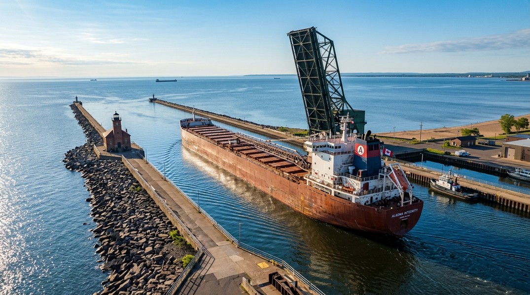
Step 6: Head to Canal Park at the right time. With a live ETA in hand, you know when to arrive. The Duluth Aerial Lift Bridge typically raises about 10-15 minutes before a vessel passes through, giving you a visual cue on the ground.
Vessel Types to Expect at the Duluth Canal
Understanding what you are looking at makes ship watching more rewarding.
Lake freighters (lakers) are the most common vessels at Duluth. They are purpose-built for the Great Lakes and typically stretch 600-1,000 feet in length. Self-unloaders are the most recognizable type: they carry a conveyor belt system that allows them to discharge cargo without dock cranes. You will often see them loading iron ore pellets at the docks on the Duluth side before heading to steel mills in Indiana or Ohio.
Salties are oceangoing bulk carriers or general cargo ships that enter the Great Lakes through the St. Lawrence Seaway. They are generally smaller than lakers because of the Seaway's lock dimensions. Spotting a saltie with a foreign flag from an unexpected country is one of the highlights of canal watching. Salties typically appear at Duluth between spring Seaway opening (late March) and mid-December when winter ice closes the system.
Tug and barge combinations also pass through the canal, though these are smaller and less frequent than the large bulk carriers.
Best Practices for Ship Watching at Canal Park
Canal Park is Duluth's most visited area and is purpose-built for ship watching. The Aerial Lift Bridge sits at the canal entrance, and the surrounding pathways give clear sightlines in both directions.
A few tips that make the experience better:
- Arrive 15-20 minutes before the AIS-calculated ETA. The ship's approach from the lake gives you time to position yourself.
- The north side of the canal offers an unobstructed view of vessels leaving the harbor headed out to Lake Superior.
- Early morning transits in calm weather are visually striking: the lake is flat, light is soft, and vessel names are easier to read.
- Bring binoculars. Even large vessels move at 8-12 knots through the canal, so there is time to read the vessel name, flag, and port of registration on the stern.
For tracking vessels you cannot identify visually, you can look up a ship's MMSI number and get detailed voyage information. Our guide to the MMSI number explains how to use that identifier to pull up a vessel in any AIS platform.
The Great Lakes Navigation Season
Great Lakes shipping is seasonal. The navigation season runs roughly from late March through January, depending on ice conditions. The Soo Locks in Michigan connect Lake Superior to the rest of the Great Lakes system, and their opening each spring marks the official start of the season.
The first oceangoing vessel to reach Duluth in 2026 arrived on April 8. In some years the first arrival comes as early as late March; in others, ice delays push it into May. Winter layup for most lakers runs December through March, so the schedule goes quiet for those months.
If you are planning a trip to Canal Park specifically to watch ships, aim for late April through October. Traffic is heaviest during summer and early fall when ore, grain, and coal shipments are at peak volume.
Tracking Duluth Vessels Without Being There
You do not need to be in Duluth to follow Great Lakes shipping traffic. Primo Nautic's live AIS map lets you search any vessel by name and watch it move across Lake Superior or navigate into the harbor, with AI-generated updates on weather conditions at the vessel's exact location, speed trends, and ETA confidence.
This is especially useful for ship enthusiasts who grew up near Canal Park and now live elsewhere, or for anyone planning a visit and wanting to monitor whether a specific ship will be in port on a particular date. Tracking a saltie's progress from the Gulf of St. Lawrence all the way into Duluth-Superior Harbor takes a few days and makes for a genuinely satisfying live voyage to follow.
Conclusion
The Duluth ship schedule gives you a starting point, but real conditions on Lake Superior rarely match the printed estimate exactly. AIS tracking converts a static timetable into a live feed: you see the vessel's position, calculate the real arrival time, and get notified the moment something changes. For anyone visiting Canal Park or following Great Lakes shipping from home, combining the schedule with live AIS data is the most reliable way to watch the right ship at the right time.
Most Recent Posts
Discover more articles from our blog.