


Precipitation
Precipitation in general
Precipitation refers to the groups of water particles in liquid or solid form which fall from the clouds to the Earth surface or build up on objects and soil from the air. They are followed by the occurrence of virga, particles that fall from clouds and do not reach the Earth's surface, the occurrence of fog that is scattered in the atmosphere or strong wind, of sea smoke and snow blizzard, wind which elevates from the Earth's surface. All these atmospheric phenomena together form the group called hydrometeors.
Processes that allow the formation of bigger cloudy particles which can lead to precipitation are: pre-distillation of water vapor from warm droplets to cold droplets, pre-distillation of water vapor from droplets to ice crystals, pre-distillation of water vapor from smaller to larger droplets, the attraction of particles of opposite electrical charge, coagulation, concretion (coalescence), juxtaposition, accumulation (aggregation).
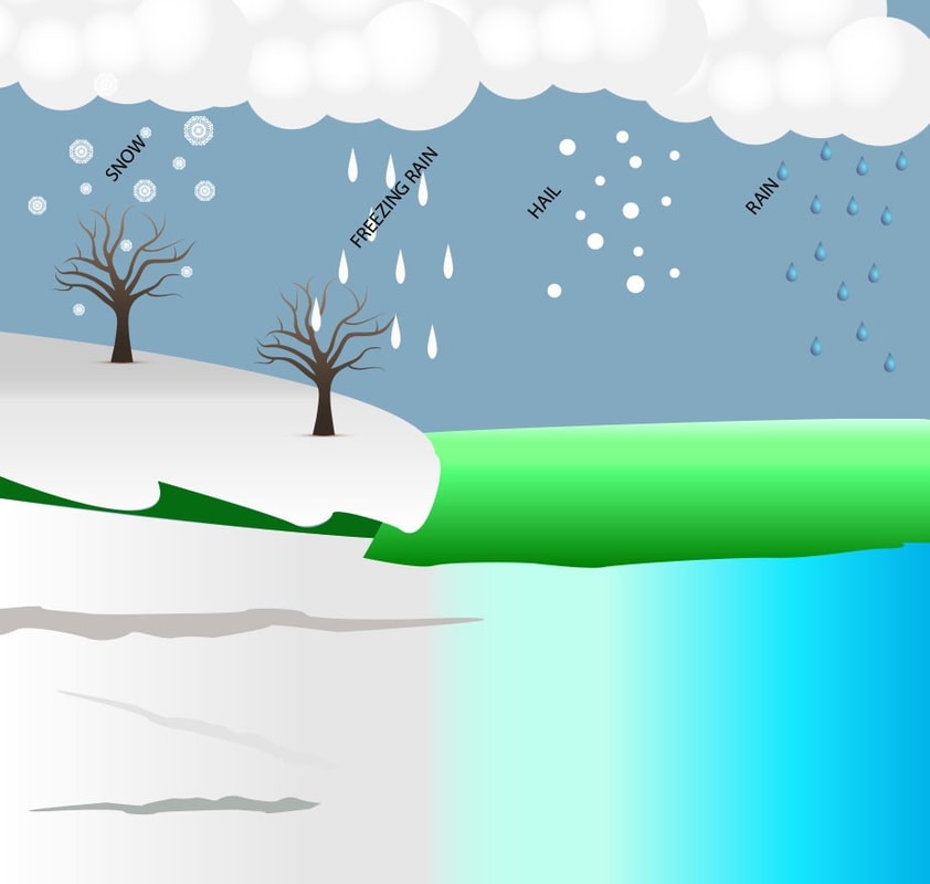
Precipitation most easily falls from mixed clouds because of the occurrence of basic processes suitable for the formation of precipitation. Taking into account the speed of freezing and deposition, different ice particles are formed. In that case, the molecules of air remain between individual frozen droplets (opaque or white) what results in snow, sleet and granular snow. If such elements stay in the cloud when temperature reaches 0° C, snowflakes will be formed. However, sleet also may occur, and it is created if the process of freezing is slow, which means that a particular quantity of water is poured onto the crystal and the following gradual freezing leads to layers of semi-transparent or transparent ice.
The combination of the above-mentioned processes leads to hail. Precipitation forms found on the ground are dew and frost. Condensation of water vapor results in dew, while frost is formed when water vapor changes directly into a solid state on the Earth's surface or other hard surfaces whose temperature is lower than 0° C. Cold objects can be covered with hoar frost if a cloud is very low, capturing all the objects along the ground. We distinguish three types of precipitation according to the way they fall: drizzle - tiny little precipitation that falls low speed, almost floats; moderate - precipitation are visible and are falling at an observable pace; shower - the precipitation of great strength.
The intensity or strength of precipitation shows the amount of precipitation that falls in a unit of time. A daily occurrence of precipitation varies because it depends on the local conditions. There are terrestrial and marine types of daily occurrences. Terrestrial type shows that the most precipitation falls in the afternoon, while the marine type displays that the most precipitation falls in the morning or during the night.
Precipitation types
The different types of precipitation frequently include the character or phase of the precipitation falling to ground level. Three distinct ways in which precipitation can occur exist.
Convective precipitation is usually more intense and shorter than stratiform precipitation. Orographic precipitation happens when moist air is forced upwards over ascending terrain, such as a mountain.
Convective precipitation happens when air moves upward vertically through the (brief) self-sustaining mechanism of alteration (convection). Stratiform precipitation happens when hefty air masses ascent diagonally as larger-scale aerial dynamics force them to move over each other. Orographic precipitation is very much alike, except the upwards motion is forced when a moving airmass confronts the rising slope of a surface such as a mountain ridge.
Precipitation can fall in liquid or solid phases or shift between them at the freezing level. Liquid precipitation includes rain, drizzle and dew. Rain or drizzle which freezes is known as freezing rain or freezing drizzle. Frozen precipitation includes snow, hail, ice crystals, ice pellets (sleet), and graupel. Their intensities are classified either by visibility limit or by speed of fall.
World distribution of precipitation
The annual average precipitation over the whole Earth is about 100 cm (39 inches) but distributed unequally. The highest levels of precipitation are found in the equatorial zone and the monsoon area of Southeast Asia. Moderate amounts of precipitation occur in middle latitudes, but only a small amount falls in the desert areas of the subtropics and around the poles.
Since rainfall results from the rising and cooling of moist air, the areas of heavy rainfall pinpoint regions of rising air, whereas the deserts appear in regions in which the air is warmed and dried during lowering. In the subtropical areas, the trade winds bring a lot of rain to the east coasts of the continents, but the west coasts tend to be dry. However, in high latitudes the west coasts are mainly wetter than the east coasts. Heavy rain tends to happen on the windward slopes of mountain systems but only sporadically on the lee sides.
The result of the rising and descending air zones are latitude bands with distinguishing precipitation characteristics:
- 0-5° latitude: wet all year (rising zone)
- 5-20° latitude: wet summer (rising zone), dry winter (descending zone)
- 20-30° latitude: dry all year (descending zone)
- 30-50° latitude: wet winter (rising zone), dry summer (descending zone)
- 50-60° latitude: wet all year (rising zone)
- 60-70° latitude: wet summer (rising zone), dry winter (descending zone)
- 70-90° latitude: dry all year (descending zone)
Measurement of precipitation
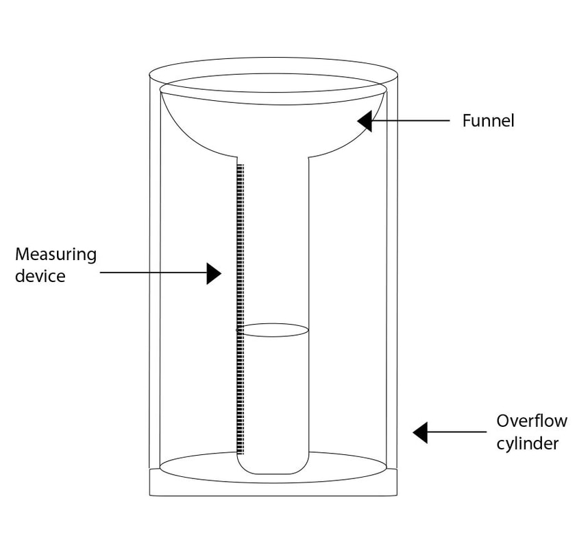
Precipitation is measured by measuring the amount of water sediment that falls onto the flat Earth's surface in a relatively longer period. The quantity of water sediment that falls in a smaller unit of time is called the intensity of precipitation. The height is a unit of precipitation expressed in millimetres and corresponds to the number of water gallons on a square meter. The amount of precipitation can be measured by pluviometer and ombrograph.
Pluviometer measures the total amount of precipitation which has fallen during some time, while ombrographs, on the other hand, continuously record the amount of precipitation and its strength. The record of the ombrograph is called ombrogram.
Hellman's pluviometers whose size of the opening is 200 cm2 and is located on the pillar high one meter is most used. It is usually located at the point where there is no strong wind, and which is away from the surrounding objects.
The totalizer is used to measure the amount of precipitation in inaccessible locations (regions). It consists of a large area which can receive up to 100 litres of water, which means that it can receive precipitation larger than 5000 mm. It is set to an altitude higher than 3 meters because of the snow, and the solution of CaCl2 is put into it to prevent refreezing. Also, there are other instruments such as pluviographs, which work on the principle of bobber, and weighing precipitation gauge which works on the principle of the scale.