Panama Canal Map: Ships, Transit and Traffic
Every Panama Canal map tells the same story: a narrow blue line cutting through a thin strip of land in Central America, connecting two oceans and carrying nearly 5% of all global maritime trade. The reality behind that line is one of the most complex waterway systems ever built, where massive ships are physically lifted 26 metres above sea level, floated across an inland lake, and lowered back down on the other side.
Understanding how the Panama Canal works makes it far easier to track ships passing through it. Whether you're following a cargo shipment, watching a cruise ship transit the locks, or simply curious about what appears on an AIS map near Colón or Balboa, this guide covers everything you need to know: the canal's geography, how ships actually move through the locks, what vessel traffic looks like by type and volume, and how live AIS tracking lets anyone watch a transit in real time.
What Is the Panama Canal?
The Panama Canal is an 82-kilometre (51-mile) artificial waterway crossing the Isthmus of Panama. It connects the Caribbean Sea on the Atlantic side with the Gulf of Panama on the Pacific side, allowing oceangoing ships to avoid the far longer route around Cape Horn at the southern tip of South America. A vessel travelling from New York to San Francisco saves roughly 7,800 miles by going through Panama rather than around South America.
France attempted to build the canal in the 1880s under Ferdinand de Lesseps, the engineer behind the Suez Canal. The project collapsed under the weight of cost overruns, disease, and engineering challenges that a sea-level design could not solve. The United States took over in 1904 and switched to a lock-and-lake design centred on the Chagres River, officially opening the waterway on 15 August 1914, according to Encyclopaedia Britannica. The first official transit was made by the SS Ancon.
Panama took over full control of the canal on 31 December 1999, under the Torrijos-Carter Treaties. Today the waterway is operated by the Panama Canal Authority (ACP), which manages everything from pilot assignments and toll collection to water conservation and lock maintenance.
The economic stakes are significant. Roughly 12,000 to 15,000 oceangoing vessels transit the canal each year, representing approximately 3-5% of global maritime trade by volume. The United States and China are consistently the largest users by cargo volume, with U.S. Gulf and East Coast to Asia routes accounting for a large share of container and energy traffic. The canal's toll revenue runs into the billions of dollars annually and contributes a substantial portion of Panama's national income.
The 2016 Expansion
The original canal could accommodate vessels up to approximately 294 metres long and 32.3 metres wide, a size class known as Panamax. Larger ships simply had no way through. The Third Set of Locks Project, approved in 2006 and completed in 2016, added an entirely new pair of lock complexes capable of handling ships nearly twice as wide. The expansion opened to commercial traffic on 26 June 2016 and transformed the canal's capacity, particularly for container ships, LNG carriers, and large bulk carriers.
Panama Canal Map: Location and Key Locks
On a Panama Canal map, the waterway runs in a broadly southeast direction rather than straight east-west, which surprises many first-time viewers. The Atlantic entrance near Colón sits at approximately 9.36°N, 79.92°W. The Pacific entrance near Balboa is at roughly 8.95°N, 79.56°W. The Pacific terminus is actually about 40 kilometres east of the Atlantic terminus, not to the west as geography might suggest.
The canal's operational length from shoreline to shoreline is approximately 80-82 kilometres. The route begins at Limón Bay on the Atlantic side, passes through the lock complexes, crosses the large Gatun Lake, narrows through the Culebra Cut (also called Gaillard Cut), and exits via the Gulf of Panama near Panama City.
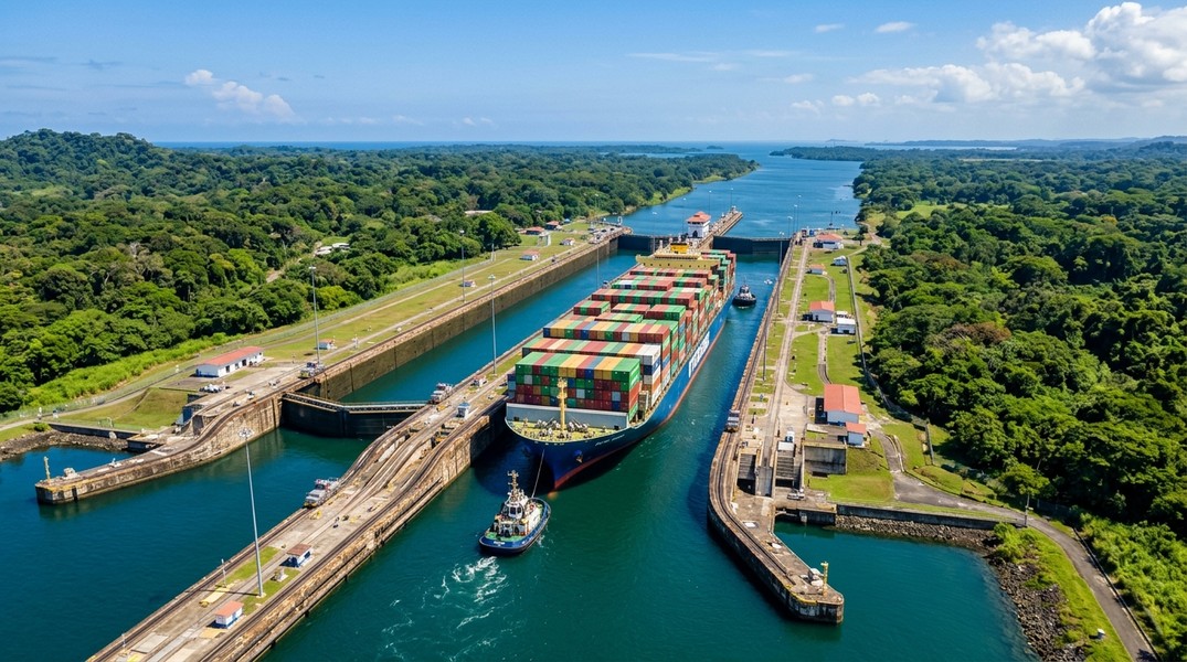
The Three Original Lock Complexes
Three sets of original locks step ships up and down across the elevation difference between sea level and Gatun Lake:
- Gatun Locks (Atlantic side): A three-step flight lifting vessels approximately 26 metres from sea level to Gatun Lake. Each chamber is roughly 320 metres long and 33.5 metres wide, enough to fit a Panamax ship with only a few feet to spare on each side. Located about 11 kilometres from the Atlantic entrance.
- Pedro Miguel Locks (Pacific side): A single step lowering ships roughly 9 metres from Gatun Lake level down to Miraflores Lake, a small intermediate body of water.
- Miraflores Locks (Pacific side): A two-step flight lowering vessels the remaining distance to Pacific sea level, near the port of Balboa and the Bridge of the Americas.
The 2016 Expansion Locks
The newer Agua Clara Locks on the Atlantic side and the Cocolí Locks on the Pacific side each use three large chambers. Unlike the original locks, which use electric locomotives called "mules" to guide ships sideways, the new locks rely on powerful tugboats for lateral control. The expanded locks also include water-saving side basins that recycle a significant portion of the freshwater used in each lockage, reducing strain on Gatun Lake's reserves.
Gatun Lake
Gatun Lake sits at the heart of the canal. It was formed by damming the Chagres River with the Gatun Dam, flooding a large valley to create an inland body of water covering approximately 430 square kilometres. Ships transit most of the canal's length by simply sailing across this lake, which sits 26 metres above sea level. The lake also serves as the canal's primary freshwater source: every time the original locks cycle, an estimated 200 million litres of freshwater flow from the lake to the sea.
This dependency on Gatun Lake makes the canal vulnerable to drought. Severe dry spells in 2019 and again in 2023-2024 forced the ACP to lower permitted ship drafts and reduce daily transit slots, causing significant queues and pushing some cargo onto alternative routes.
How Ships Transit the Panama Canal
A canal transit is not something a ship's captain simply decides to do at the last minute. The process is formal, highly coordinated, and begins well before any vessel arrives at the canal entrance.
Booking and arrival: Most large commercial vessels book transit slots in advance through the ACP. Operators submit detailed vessel information including type, dimensions, draft, and cargo. Ships without reservations join a priority queue, with passenger and cruise ships often given preferential scheduling. Vessels typically anchor in designated waiting areas at Cristóbal (Atlantic) or Balboa (Pacific) until their transit window opens.
Canal pilots: Every vessel transiting the canal must carry one or more Panama Canal pilots for the entire passage. These specialists are among the most trained maritime pilots in the world, qualified to handle large ships in the confined chambers and narrow channels of the canal. The pilot assumes navigational control for the transit, working closely with the ship's captain and crew.
Through the original locks: Once the vessel enters a lock chamber, it is positioned with the help of mule locomotives on the lock walls. These electric machines run on tracks and hold the ship centred in the chamber via steel wires. When the gates close, water flows through culverts in the chamber floor, raising or lowering the ship to match the water level in the next section. This cycle repeats through each step of each lock.
Crossing Gatun Lake and Culebra Cut: Between lock complexes, ships navigate through buoyed channels on the lake and through the Culebra Cut, a heavily excavated channel through the continental divide. Speed limits and passing rules apply throughout, particularly in the narrow sections where two-way traffic is restricted.
Through the new locks: In the Agua Clara and Cocolí lock complexes, tugboats replace mules as the primary means of lateral control. A single Neopanamax container ship occupies most of a lock chamber, leaving only a few metres of clearance on each side, so precise tugboat positioning is essential. The chamber gates are rolling steel structures weighing up to 3,000-4,000 tonnes each.
Exit: After clearing the last lock on the far side, the canal pilot disembarks via a small pilot boat, and the ship continues its ocean voyage under its own navigation team.
The end-to-end passage for a ship that has already been assigned a transit slot typically takes 8-10 hours. Total time in the canal system, including waiting at anchor, can range from under a day for well-scheduled transits to several days during periods of high congestion or water restrictions.
Transit Costs
Tolls at the Panama Canal are calculated based on vessel type, capacity, and cargo. Container ships pay largely on TEU capacity. Bulk carriers and tankers are typically charged per ton of cargo or net tonnage capacity. Cruise ships pay per passenger berth.
Large Neopanamax container ships can face tolls in the hundreds of thousands of U.S. dollars per transit. The ACP also offers auctioned priority slots; during the 2023-2024 drought, when regular transit capacity was sharply reduced, priority auction prices surged significantly as operators competed to avoid weeks-long delays. Operators check current ACP tariff schedules for up-to-date rates, which are periodically revised.
Panamax and Neopanamax: Ship Size Limits
The canal effectively defines two generations of ship design. Every maritime engineer working on large vessel design has always had to answer one question: does it fit through Panama?
Panamax ships are built to the maximum dimensions the original locks can accommodate: approximately 294 metres long, 32.3 metres wide (beam), and a maximum draft of about 12 metres. For container ships, this typically translates to a capacity of around 4,500-5,000 TEU. For many years, Panamax was essentially the upper limit of large commercial ship design.
Neopanamax (also called New Panamax) refers to the size class the 2016 expansion accommodates. The indicative maximum dimensions are roughly 366 metres long, 49 metres wide, and 15.2 metres draft under normal water conditions. This allows container ships carrying up to approximately 13,000-14,000 TEU, as well as large LNG carriers and bulk carriers that previously had no viable Panama route.
The distinction matters on an AIS tracking screen. When you see a vessel identified as a large container ship making slow, deliberate movements through the lock sections on a Panama Canal map, its size class determines which set of locks it uses and how much clearance the crew is managing.
Panama Canal Ship Traffic: Volume and Vessel Types
In a typical year, roughly 12,000 to 15,000 oceangoing vessels transit the canal. This represents a significant portion of the world's containerized trade, liquid bulk movements, and dry bulk commodity flows between the Pacific and Atlantic basins.
Container ships account for a large share of total tonnage and represent the highest-value cargo. Major lines including Maersk, MSC, CMA CGM, COSCO/OOCL, Hapag-Lloyd, and Evergreen all route numerous services through Panama. Many container ship services between Asia and the U.S. East Coast and Gulf Coast are now designed specifically around Neopanamax vessels to optimize canal economics.
Dry bulk carriers move grain from U.S. Gulf ports to Asian buyers, coal, ores, and other commodities that form the backbone of global raw material trade. Tankers carry crude oil, refined petroleum products, and chemicals. LNG carriers have become one of the fastest-growing user classes since the expansion, as U.S. Gulf liquefaction terminals send increasing volumes of natural gas to Asian buyers via the shortest available route.
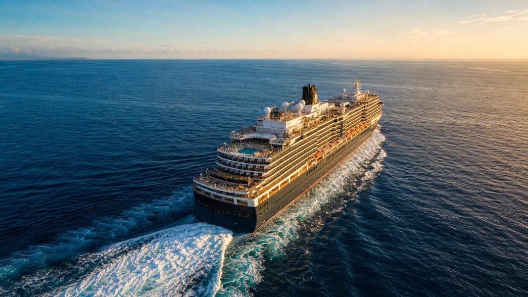
Car carriers and cruise ships add to the diverse traffic mix. Cruise ships transit both as repositioning voyages and on dedicated Panama Canal itinerary sailings, particularly during the Northern Hemisphere winter season. For cruise passengers, a full canal transit is a prized voyage in itself, offering views of engineering infrastructure you simply cannot see from any road.
The 2023-2024 Drought Impact
The canal's dependence on Gatun Lake became starkly apparent during the severe drought of 2023-2024. Exceptionally low rainfall driven by El Niño conditions reduced lake levels significantly, forcing the ACP to lower the maximum permitted draft for transiting vessels and cut the number of daily transit slots, at one point reducing daily transits to as few as 18-22 ships against a typical capacity of 35-38.
The knock-on effects rippled through global shipping. Many container services rerouted via the Suez Canal. Bulk operators sent ships around the Cape of Good Hope. LNG cargoes destined for Asia by the shortest route faced weeks-long delays or diversions. Vessels lined up in anchorages at both canal entrances, and those spots were clearly visible on AIS maps as dense clusters of stationary ships.
The situation highlighted the canal's role as a critical chokepoint in global supply chains, alongside the Strait of Hormuz, the Strait of Malacca, and the major shipping lanes connecting production and consumption regions worldwide.
How to Track Ships in the Panama Canal Live
The Panama Canal is one of the most AIS-dense corridors on the planet. Nearly every commercial vessel over 300 gross tonnes on an international voyage is required by IMO regulations to carry an AIS transponder, and the canal system itself runs a sophisticated Vessel Traffic Management System (VTMS) that integrates AIS data with radar, cameras, and communications to sequence transits safely.
AIS transponders broadcast data packets via VHF radio, picked up by coastal receivers, other ships, and satellite networks. Near the Panama Canal, shore-based receivers cover the entire route. What you see on a live AIS map reflects data transmitted every few seconds by moving vessels and every few minutes by anchored or stationary ones.
What AIS shows you at the canal: Each vessel on an AIS-enabled Panama Canal map displays its name, type, position, speed over ground, course, heading, navigational status (underway, at anchor, moored), and the destination and ETA entered by the crew. Many platforms enrich this with static data: vessel dimensions, flag, gross tonnage, and build year from maritime registries.
When you zoom into the canal on a live map, you can see convoys of ships moving in sequence through the lake, slow-moving vessels inside lock approaches, and tugboats clustering near lock entrances before and after a large transit.
For cargo professionals monitoring a specific shipment, apps like Primo Nautic go beyond raw AIS position dots. Primo Nautic translates AIS data into personalized, human-friendly updates adapted to your tracking purpose. Whether you're a logistics team monitoring a container shipment's approach to the locks, or a family member following a cruise ship's transit, the AI reads the vessel's position, speed, and route context to generate updates that make sense without requiring maritime expertise.
Tracking a cargo vessel through the Panama Canal with a dedicated app reveals information the raw position dot doesn't communicate on its own: whether the ship is waiting at anchor in the Cristóbal or Balboa queue, how far it is from its first lock, and what the realistic arrival window looks like at the destination port given the transit time ahead.
What You See on a Panama Canal AIS Map
Knowing the geography makes the AIS view much more readable. At any given moment, a live Panama Canal map typically shows several distinct patterns.
At the Atlantic entrance near Colón, you'll often see a scatter of anchored ships off Limón Bay waiting for their transit slot. During periods of congestion or drought-related restrictions, this cluster grows notably. During normal operations, it turns over steadily as convoys are assembled and dispatched.
Along the Gatun Lake section, look for a loose convoy string following the marked channel: vessels spaced at safe intervals, moving at reduced speed through the wide lake. Near the Culebra Cut, the spacing tightens as the navigable channel narrows.
At the lock complexes themselves, movement is extremely slow and deliberate. A large Neopanamax container ship entering Agua Clara or Cocolí Locks may take 20-30 minutes to complete a single chamber. If you zoom in, you can often see the heading indicator of a ship gradually swinging as it's positioned by tugs.
At the Pacific entrance, a similar anchorage cluster forms off Balboa. Ships that have completed the transit and are heading for Pacific ports depart this area after the pilot disembarks.
Watching this all unfold on a live map is one of the most visceral ways to understand how global trade actually moves. The live container tracking tools that show a Neopanamax ship slowly stepping through the locks are drawing on the same AIS infrastructure the canal authority uses to manage the entire system in real time.
Primo Nautic's tracking purposes let you decide how you want to engage with that data. A ship enthusiast gets context about the vessel's history and route; a cargo monitor gets logistics-focused updates about ETA and delay risk; a family member watching a cruise ship gets reassuring, jargon-free progress updates as the ship moves from ocean to ocean.
Panama Canal Facts and Records
The canal has accumulated an impressive record of engineering and operational statistics since it opened in 1914.
The original lock chambers measure approximately 320 metres long by 33.5 metres wide, with a depth of about 12 metres. Each original lockage uses roughly 200 million litres of freshwater, all flowing by gravity through culverts beneath the chamber floor. The new locks reduce this through water-saving side basins that store and recycle a portion of the water from each cycle.
Gatun Lake, the canal's central feature, covers approximately 430 square kilometres at an elevation of 26 metres above sea level. It was the largest man-made lake in the world for many years after its creation.
The average ocean-to-ocean transit time, once a vessel has been assigned a slot and cleared the first lock, is 8-10 hours. Total time in the canal system from first anchorage to exit averages around 24 hours under normal conditions, though congestion and drought restrictions have extended this considerably in recent years.
The canal's annual transit count has generally ranged from 12,000 to 15,000 oceangoing vessels, though this figure dipped significantly during the 2023-2024 drought period. The transit count excludes small craft using the simplified arrangements available to yachts and other non-commercial vessels.
The Neopanamax expansion, completed in 2016, increased the maximum container ship capacity transiting the canal from roughly 5,000 TEU to approximately 13,000-14,000 TEU, fundamentally changing trade route economics for Asia-to-U.S. East Coast and U.S. Gulf LNG export routes.
Conclusion
The Panama Canal is a living piece of infrastructure: constantly in motion, constantly managing the tension between the enormous volume of trade that wants to pass through it and the physical and environmental constraints that limit how much it can accommodate.
A Panama Canal map, whether a static diagram or a live AIS view, reflects all of this at once. The anchored ships waiting outside Colón or Balboa represent demand. The slow convoys crossing Gatun Lake represent capacity being carefully managed. The giant container ships and LNG carriers fitting through the new locks by metres on each side represent a century of engineering refinement.
Understanding the locks, the lake, the size limits, and the traffic patterns makes any ship tracking experience at the canal more meaningful. The AIS dot moving at three knots through a lock chamber becomes a 366-metre vessel being positioned by four tugboats into a space engineered to a tolerance measured in centimetres.
Most Recent Posts
Discover more articles from our blog.