


Cruise Ship in Bad Weather: What Happens at Sea
A cruise ship in rough seas rolls differently than it does in calm water, but modern ships are engineered for exactly this. When your loved one is on board during a storm and you're watching the forecast from home, it helps to know what "rough seas" actually means and what the ship is doing about it.
This guide covers the Beaufort scale in plain terms, how cruise ship stabilizers work, what passengers experience during heavy weather, when ships change course, and how you can check live conditions at the ship's exact location.
What Counts as Rough Seas for a Cruise Ship?
The maritime industry uses the Beaufort scale to describe wind and sea conditions. For context, a pleasant sailing day sits around Force 3-4 with small waves up to about half a meter. Things change meaningfully at Force 6.
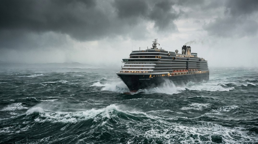
At Force 6 (winds 22-27 knots), large waves form with white foam crests. Most passengers feel the motion, but the ship handles it without issue. Force 7 brings sea heaps and foam streaks, and while a small yacht would be fighting, a large cruise ship is still well within its operating range. Force 8 (34-40 knots) is where things get genuinely uncomfortable. Wave heights that affect passengers start above 2 meters, with serious discomfort above 3 meters.
What's considered rough seas internally by cruise lines is tied to wave height relative to the ship's size and route. Royal Caribbean employs dedicated meteorologists and fleet operations centers specifically to route ships around heavy weather before it becomes an issue for passengers. This kind of proactive weather routing is standard across major cruise lines and is one of the primary reasons serious weather incidents are rare.
The key threshold to understand is the difference between "uncomfortable" and "dangerous." Force 6-7 seas are uncomfortable for some passengers but well within the operational envelope of any modern cruise ship. Force 9 and above, particularly combined with equipment failure, is where real risk emerges.
How Cruise Ships Are Built for Rough Weather
Modern cruise ships are not just large: they're specifically engineered to stay stable in poor conditions. The hull design itself plays a major role. V-shaped bows cut through waves rather than slamming into them, and the wide beam of a large ship provides natural buoyancy and resistance to roll.
The critical technology is the stabilizer fin system. Active fin stabilizers extend from the hull underwater and adjust continuously via hydraulics, counteracting rolling before passengers feel it. Gyroscopic stabilizers use spinning flywheels as internal damping systems on some vessels. Together, these allow a modern cruise ship to handle rolls of 20-30 degrees without approaching the stability limits that would put the vessel at risk.
Weight distribution matters too. Engines and fuel tanks sit low in the ship, keeping the center of gravity below the waterline. Ballast systems pump water between tanks to adjust trim dynamically as conditions change.
Size is a genuine advantage. A 113,000 gross ton vessel like Carnival Splendor has far more inertia than a smaller ship, so pitch and roll are reduced simply by mass. Azimuth thrusters provide precise maneuvering capability that older propulsion systems couldn't match, keeping the ship positioned correctly relative to wave direction and swell.
To follow conditions as they develop, you can learn how AIS tracking works and understand what the live position data actually tells you about where the ship is relative to any developing weather system.
What Passengers Experience During Heavy Weather
When wave heights reach 2-3 meters, passengers feel a noticeable rolling and swaying. On lower decks and in the ship's interior it registers as a gentle, persistent rocking. On outer decks or upper floors, the motion is more pronounced, with spray and occasional lurching. Stabilizers minimize this significantly but cannot eliminate it entirely.
Seasickness is the primary concern for passengers. Roughly 25-50% of those on board experience nausea during Force 5 and above conditions, with higher rates among first-time cruisers. Children can be particularly susceptible. The worst cases involve confused seas, where swells arrive from two different directions simultaneously, creating an irregular motion that stabilizers struggle to compensate for fully.
The crew response during heavy weather is methodical. Loose items are secured throughout the ship. Deck access gets restricted when conditions are dangerous enough that passengers could be swept or fall. Buffet lines are often simplified or closed entirely to remove trays and dishes that could slide or shatter. Medical plans activate for potential mass casualty situations, as falling is the primary injury mechanism during heavy weather events.
Real incidents illustrate what Force 8-9 looks like in practice. When the Spirit of Discovery encountered heavy weather in the Bay of Biscay, propulsion failure during the storm caused violent rolling and over 100 passenger injuries from falls. These events are rare, but they happen, and they underscore why weather routing exists as a standard operational priority.
When Do Cruise Ships Divert or Change Ports?
The captain has absolute authority over routing decisions. No cruise line executive overrides a captain's weather call. Fleet operations centers provide continuous forecast data, and many lines have dedicated meteorologists analyzing systems days in advance, but the final decision sits on the bridge.
Port cancellations and route diversions typically trigger at Force 8 winds combined with swells over 3-5 meters, particularly when those conditions would make tendering or docking unsafe. A port without a proper pier, where passengers must take a small boat from ship to shore, becomes inaccessible well before the sea state would concern the ship itself.
Serious weather encounters across the cruise industry occur in roughly 1-2% of sailings through high-risk areas like the Bay of Biscay, Drake Passage, or certain North Atlantic routes. Port cancellations across all itineraries happen in under 5% of voyages annually. The industry's weather routing infrastructure exists precisely to keep those numbers low, and most passengers complete entire cruises without experiencing anything beyond moderate choppiness.
When a diversion does happen, passengers are typically notified through the ship's public address system with the captain's announcement. Cruise lines are not required to compensate for weather-related port changes, though some offer onboard credit as a goodwill gesture.
How to Read Maritime Weather for a Cruise Route
For families tracking a cruise ship, the regional forecast you see on a phone weather app is rarely the right tool. Open ocean conditions differ significantly from coastal forecasts, and the specific location of the ship matters more than the general region.
NOAA buoys provide real-time maritime observations positioned across major ocean regions, including wave height, swell period, wind speed, and sea surface temperature. These measurements reflect actual conditions rather than model predictions, making them useful for understanding what a ship in a particular area is actually encountering.
The challenge is that cross-referencing buoy data with a ship's position requires knowing where the ship actually is at any given moment. Cruise line apps provide some position information, but updates are often infrequent and the weather overlay is minimal. Independent vessel tracking tools that combine live AIS position with on-location weather data give a much more complete picture.
The three data points that matter most are wave height, wind speed, and swell direction. Wave height above 2 meters signals uncomfortable conditions. Wind speeds above 22 knots (Force 6) mean rough weather is active. Swell direction matters because confused seas from multiple directions create worse motion than a single swell of the same height.
How to Check Live Weather at Your Ship's Location
Primo Nautic is built specifically for this use case. Rather than showing a generic regional forecast, it displays the real-time weather at the exact coordinates where the tracked vessel currently sits: temperature, wind speed, sea state, and visibility, adapted to the context of why you're tracking.
For a family member on a cruise, Primo Nautic's AI translates that raw weather data into something meaningful: whether the ship is in calm seas, whether conditions are building ahead on the route, and what the outlook looks like for the next port. You're not left interpreting wave heights and wind knots yourself.
To understand how to track a cruise ship in real time alongside its weather conditions, the combination of live AIS position with on-location weather data gives you a clearer read on what's actually happening at sea than any forecast for the broader region.
Knowing the sea state at the ship's exact position, rather than the general area, tells you whether the captain has successfully routed around a storm system or is sailing through it. A weather system can span hundreds of miles; the ship's specific track within or around it is what matters.
What Rough Seas Actually Mean for Safety
Modern cruise ships do not capsize in bad weather under normal operational circumstances. The engineering margins built into these vessels are substantial, and stability limits account for conditions far beyond what any scheduled itinerary would deliberately sail through.
What bad weather does create is a higher risk of passenger injuries from falls, seasickness that significantly degrades the experience, and potential schedule disruption through port changes or speed adjustments to smooth the ride. The Spirit of Discovery incident involved simultaneous propulsion failure during Force 9 conditions, a compound scenario rather than weather alone.
The cruise industry invests heavily in weather routing and advanced navigation systems specifically to avoid exposing ships to the most severe conditions. The vast majority of weather-related disruptions on cruises result in nothing more than a rough night and an itinerary adjustment.
For families watching a forecast and worrying about someone at sea, the most useful frame is this: cruise ships are built for rough weather, captains are empowered to avoid it when possible and manage it when not, and the conditions that cause serious problems require a combination of extreme weather and equipment failure that is statistically rare.
In Summary
Rough seas for a cruise ship start at Beaufort Force 6-7, where stabilizer fins and hull design do the work passengers don't feel. Serious conditions at Force 8 and above can cause discomfort and injury, but the captain controls routing and diversions to minimize that exposure. Port cancellations happen in under 5% of voyages. For the moments when you want to know exactly what the weather is like at the ship's location, live AIS tracking with on-location weather data gives you a more accurate picture than any regional forecast.
Most Recent Posts
Discover more articles from our blog.