


Celestial navigation
Celestial definitions
Methods of astronomical navigation are an assemblage of mathematical principles which, by following the regular position changes of celestial bodies, enable orientation on the open sea. The basic unit in navigation for measuring distances in general is a nautical mile, ie. one minute of a large circle arc. Other coordinates used in astronomical navigation are corresponding angles.
Spherical trigonometry deals with the application of goniometric functions for solving spherical triangles. Spherical triangle is a figure in the sphere defined by three points which lie on the same main circle (the one whose plane passes through the center of the sphere). The spherical angle is formed in the average point of the two major circles, while circles form a spherical biangle. Spherical length is a smaller arc between two points on the main circle sphere expressed in angular, arched or hourly measure.
Celestial sphere
Celestial sphere is a projection of all the celestial bodies on one spherical surface. Such consideration of the celestial bodies positions greatly facilitates the study of the movement of celestial bodies, as well as solving the problem of celestial observation which does not require observing the distance of celestial bodies but only their movement directions. The position of each celestial body in the sphere is defined by the two spherical coordinates.
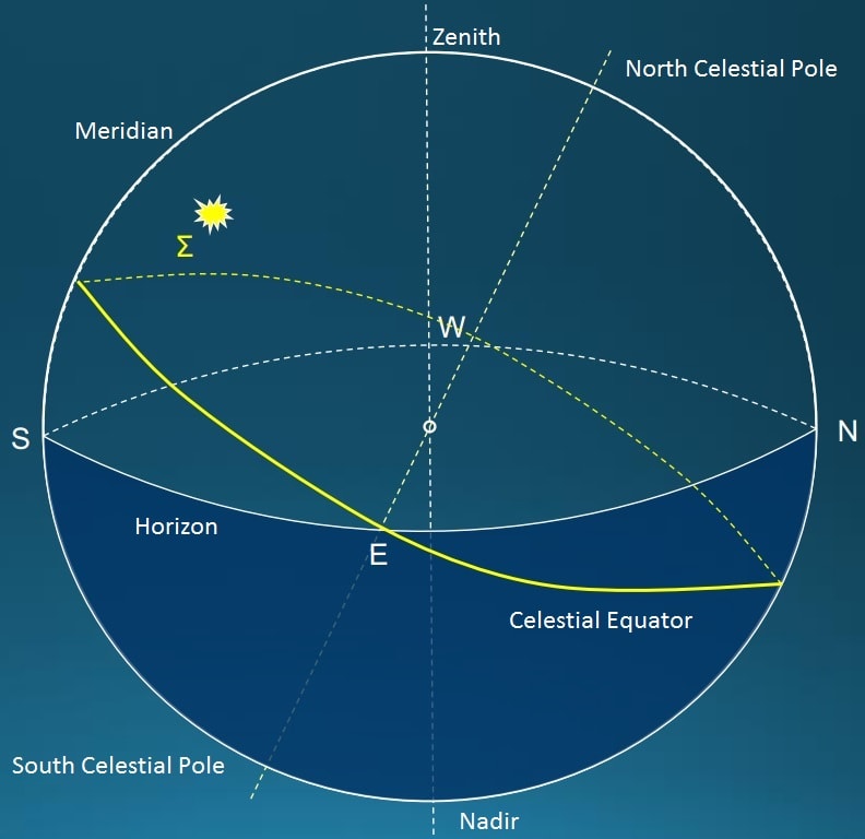
Zenith - point above the observer's head.
Nadir - point which is located in the center of the invisible part of the sphere, which is located below the observer is kind of an antipode to the zenith.
North celestial pole (Pn) - point above the north pole of the Earth.
South celestial pole (Ps) - point above the south pole of the Earth.
The projection of the Earth's equator on the sphere gives the celestial equator, and the projection of the earthly horizon gives the celestial horizon. The projection of meridian on the celestial sphere defines the celestial meridian, ie. projection of the local meridian of the observer on Earth determines the local celestial meridian. The plane in which the Earth moves around the Sun is called the ecliptic plane, and it intersects the celestial sphere on a large circle called the ecliptic.
The horizon system of coordinates
In astronomical navigation, we distinguish coordinate systems that depend on the position of the observer and the coordinate systems that do not depend on the position of the observer.
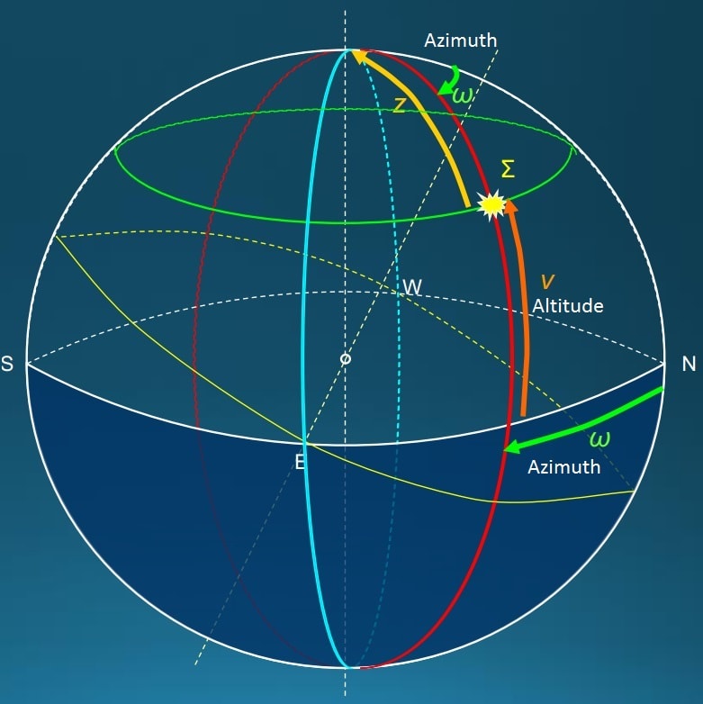
Poles of the coordinate system of the horizon are zenith and nadir. They are obtained if the perpendicular extends from the position of the observer to the celestial sphere. The basic circles of this system are celestial horizon, celestial meridian and vertical circles. Celestial horizon is a circle which is obtained if the observer's horizon plane extends to the celestial sphere. Celestial meridian is the main circle which is obtained if the observer's meridian plane extends to the celestial sphere, and there are situated zenith, nadir and celestial poles.
Basic coordinates in this system are height (H) and azimuth (W).
Altitude is the arc of the vertical circle from the celestial horizon to the center of the celestial body, or an angle at the center of the sphere between the celestial horizon and the center of the celestial body.
Azimuth of a celestial body is the arc of the horizon from the northern (or southern) point to the vertical circle on which the celestial body is situated, or the angle at the center of the sphere between north (south) point and the point of intersection of the vertical circle on the horizon.
The equator system of coordinates
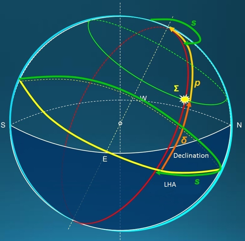
The main plane of the local-equatorial system is the plane of the celestial equator. The poles of the local coordinate system of the equator are obtained if the axis of the Earth extends to the celestial sphere, and that are north and south celestial pole. The main circles of this system are the celestial equator and the celestial meridians.
Basic coordinates in this system are declination (δ) and hourly angle (s).
Declination of the celestial body is an arc of an hourly circle from the celestial equator to the center of celestial body, or an angle at the center of the sphere between the celestial equator and the center of the celestial body. Declination of celestial body is measured from the celestial equator to the pole and it is positive if the celestial body is situated northwards from the equator (marked N), and it is negative if the celestial body is situated southwards from the equator (marked S).
Local hour angle is the arc of the celestial equator from the upper meridian to the hourly circle of the celestial body, or a corresponding angle in the center of the sphere. Hourly angle is also the angle in the pole between the upper local meridian (one that contains zenith) and the hourly circle passing through the celestial body. Hourly angle of a celestial body counts in an angular measure from 0 ° to 360 ° westwards, or from 0 ° to 180 ° eastwards and westwards.
The celestial equator system of coordinates
The main circles of celestial-equatorial system are the celestial equator and the celestial meridian of celestial body.
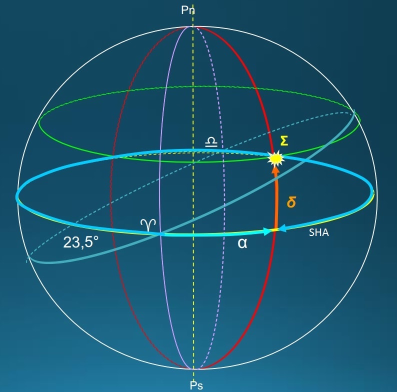
The coordinates of a celestial body in this coordinate system are: declination (δ) and sidereal hour angle (360 ˚- α).
Right ascension (RA) is the arc of the celestial equator from the vernal point to the celestial meridian passing through a celestial body, or the angle in a pole between celestial meridians passing through the vernal point and celestial body. It counts from 0° to 360° oppositely of clockwise (progressive).
Sidereal hour angle (SHA) is the arc of the celestial equator from the vernal point to a meridian which passes through the celestial body (the angle in the pole between the celestial meridians passing through the vernal point and a celestial body), and is counts from 0° to 360°.
The celestial ecliptic system of coordinates
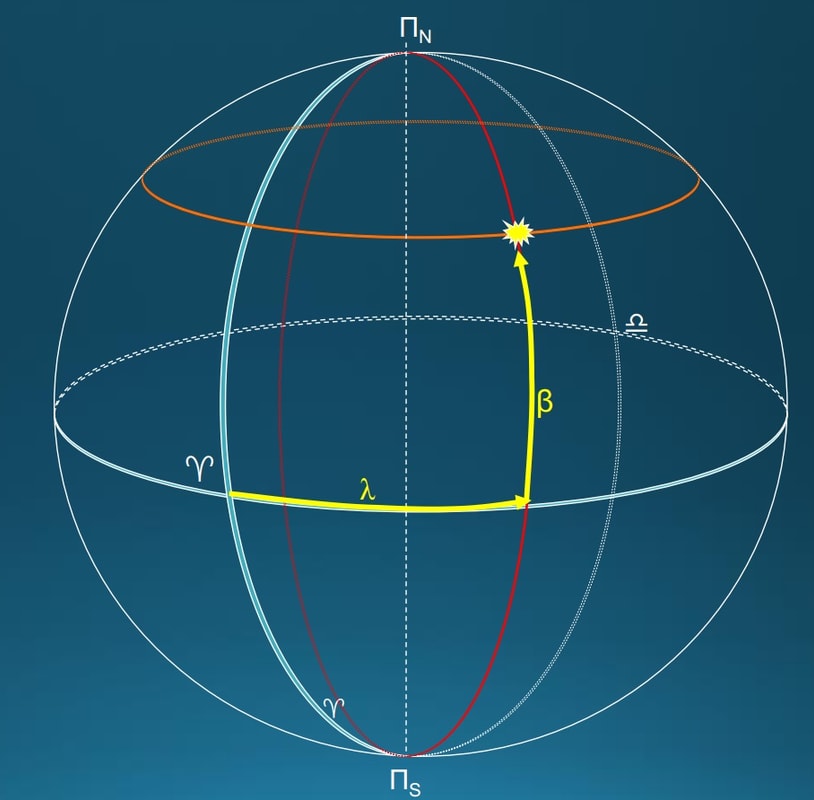
Poles of the ecliptic coordinate system are north and south poles of the ecliptic. These are the points on the sphere which can be obtained when the axis is perpendicular to the plane of the ecliptic and when it passes through the center of the Earth and extends to the celestial sphere. The basic circles in this coordinate system are the ecliptic and the meridians of the ecliptic.
Basic coordinates of this system are latitude or ecliptic width (β) and longitude or ecliptic length (λ).
Latitude of a celestial body is an arc of the meridian ecliptic from the ecliptic plane to the center of celestial body, or a corresponding angle between the ecliptic plane and the direction of the celestial body.
It counts from the ecliptic to the ecliptic pole (from 0 ° to 90 °) and it is positive if a celestial body is located in the northern hemisphere of the ecliptic coordinate system (labeled N), and it is negative if it is located on the south (labeled S).
Longitude of a celestial body is the arc of the ecliptic from the vernal point to the ecliptic meridian through a celestial body, or the angle of the ecliptic pole between ecliptic meridians passing through the vernal point and celestial body. It counts from 0 ° to 360 ° in a progressive direction (reverse clockwise).