


Suez Canal Map: Ships, Traffic and Location
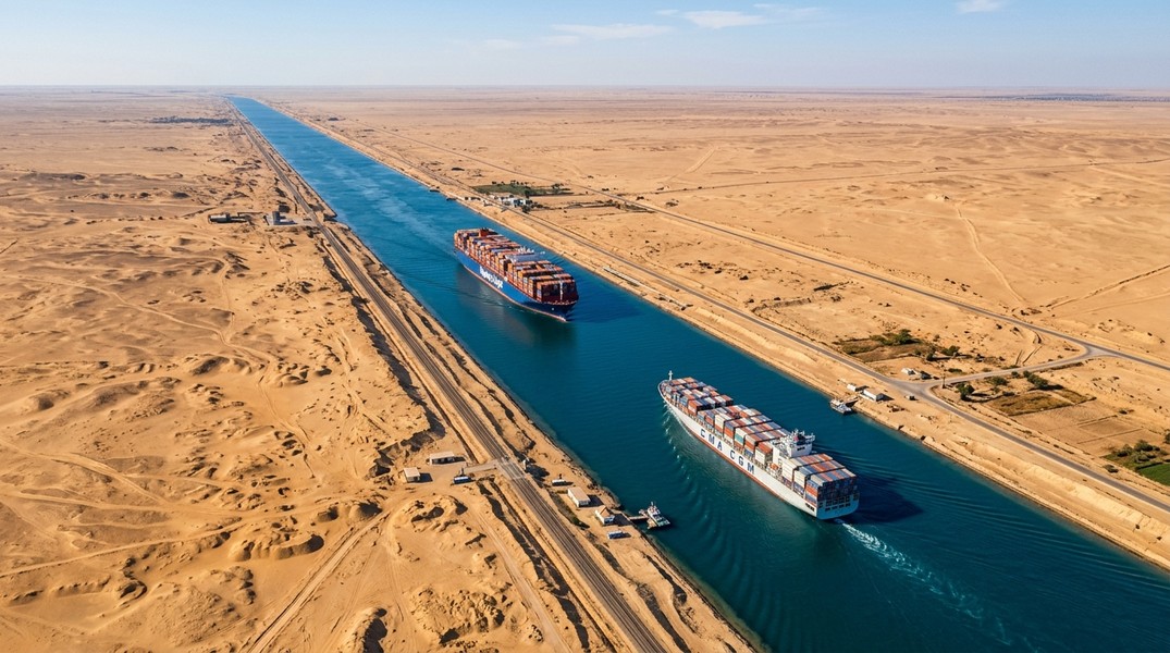
The Suez Canal is a 193-kilometer artificial waterway in northeastern Egypt connecting the Mediterranean Sea at Port Said to the Red Sea at Suez. Any suez canal map shows the same picture: a narrow north-to-south corridor cutting through Egypt's Isthmus of Suez, forming the geographic boundary between the African mainland and the Sinai Peninsula.
It is one of the most consequential shipping routes on earth. Container ships, oil tankers, bulk carriers, and cruise ships pass through it every day, saving weeks of sailing time between Europe and Asia. This guide covers where the canal sits on the world map, how it is built, which vessels use it, how much traffic moves through, and how you can watch ships transiting it live.
Suez Canal Map: Location and Geographic Overview
The canal runs north to south through Egypt's northeastern corner. Its northern terminus is Port Said on the Mediterranean coast; its southern terminus is the city of Suez, which sits at the head of the Gulf of Suez leading into the Red Sea.
On a suez canal world map, the canal lies at roughly 30° to 32° North latitude, placing it in the same horizontal band as Cairo and Tel Aviv. The narrow Sinai Peninsula lies to the east of the canal, while Egypt's Nile Delta region lies to the west. Because the Sinai Peninsula is considered part of Asia, the canal effectively marks the point where Africa ends and Asia begins. Encyclopaedia Britannica describes it as the waterway that separates Africa from Asia.
On a suez canal egypt map, look for Port Said on the Mediterranean coast and follow the thin waterway south through the Bitter Lakes, a series of hypersaline lakes the canal passes through naturally, before reaching the Gulf of Suez. That north-to-south line is the entire length of the canal.
For travelers researching cruise itineraries or cargo shipment routes, the suez canal map location is always in Egypt's northeastern tip, at the crossroads of three continents: Africa to the west, Asia to the east, and Europe just across the Mediterranean to the north.
Length, Depth, and Why There Are No Locks
The canal opened at 164 km long in 1869. A major expansion completed in 2015 added nearly 29 km, bringing the total length including dredged approach channels to approximately 193 km. That makes it one of the longest artificial waterways in the world.
Unlike the Panama Canal, the Suez Canal has no locks. It is a sea-level waterway: the Mediterranean and Red seas sit at nearly the same elevation, so ships sail straight through without being lifted or lowered between chambers. The Canal Authority describes it as the world's longest canal without locks, and the absence of locks is what makes transit relatively fast.
A typical crossing takes between 11 and 16 hours, depending on vessel size, convoy scheduling, and traffic. Ships generally move in organized convoys, with northbound and southbound groups traveling at set intervals to avoid collisions in the narrower sections.
"Suezmax" is the industry term for the largest tankers that can pass fully loaded, based on the canal's depth, beam clearance, and air draft constraints. Very large crude carriers sometimes need to partially offload to stay within allowable draft limits. The 2015 expansion improved capacity and added a parallel section for 35 km of the route, enabling limited two-way traffic in that segment.
Which Ships Use the Suez Canal?
The canal handles nearly every category of ocean-going vessel. Container ships are among the most frequent users, carrying manufactured goods on the Asia-Europe trade lane that connects Chinese factories to European ports. Oil tankers represent another major category, moving crude oil and refined petroleum products between the Persian Gulf and European refineries.
Bulk carriers haul grain, coal, ores, and metals. Product tankers carry refined fuels. Vehicle carriers, LNG tankers, and general cargo ships all use the route. On the northbound leg, typical cargoes include crude petroleum, petroleum products, coal, ores and metals, fabricated metals, wood, oilseeds, and cereals.
Cruise ships also transit the canal, most often on repositioning voyages or world cruise itineraries. For passengers, passing through the Suez Canal is memorable: a flat, narrow corridor with Egypt visible on both sides, completely unlike open-ocean sailing.
The core reason so many vessel types use the canal is time. Without it, ships traveling between northern Europe and the Indian Ocean would need to sail around the entire African continent via the Cape of Good Hope, adding roughly 10 to 15 days per voyage. For a container ship making six to eight round trips a year, that translates to thousands of extra nautical miles and significant fuel costs.
The Suez Canal fits into a global web of major corridors. For a broader view of those routes, see our guide to global shipping lanes and how traffic flows between ocean basins.
How Much Traffic Moves Through Each Day?
Traffic levels tell the story of the canal's economic importance better than almost any other number. In 2023, 26,434 vessels transited the canal, averaging roughly 72 per day. In 2024, that figure dropped to 13,213 transits, and 2025 saw 12,758.
The sharp drop between 2023 and 2024 reflects a real-world security crisis. Houthi attacks on commercial shipping in the Red Sea led many carriers to reroute their vessels around the Cape of Good Hope, bypassing the canal entirely. The disruption cut daily throughput nearly in half and demonstrated how sensitive the canal's traffic is to regional instability.
Before those disruptions, the Suez Canal handled an estimated 12 to 15 percent of global seaborne trade. The transit fees it collects represent a significant portion of Egypt's foreign currency income. When traffic drops, the financial consequences extend well beyond the canal itself, affecting port revenues, insurance markets, and logistics networks worldwide.
The most dramatic recent incident was the 2021 grounding of the Ever Given, a 400-meter container ship that blocked the canal for six days. Hundreds of vessels queued at both ends while salvage teams worked to refloat the ship. The grounding was resolved without structural damage to the canal, but the global supply chain backlog it created took weeks to clear.
A Brief History of the Suez Canal
Construction began in 1859 under Ferdinand de Lesseps, the French diplomat whose concession from the Egyptian government allowed him to build and operate the waterway. The canal opened on November 17, 1869, and transformed maritime trade almost immediately. Voyages between Britain and India that previously required months around Africa now took a matter of weeks.
For most of its early history, the canal operated under French and British control through the Suez Canal Company. In 1956, Egyptian President Gamal Abdel Nasser nationalized it, triggering the Suez Crisis. Britain, France, and Israel launched a military intervention before international pressure, led by the United States and the Soviet Union, forced a withdrawal. Egypt retained full control, and the canal became a defining symbol of postcolonial sovereignty.
Between 1967 and 1975, the canal closed as a result of the Six-Day War. Fourteen cargo ships became trapped in the Bitter Lakes for the entire duration, their crews maintaining vessels that slowly accumulated yellow sand. The group became known as the Yellow Fleet, and their eventual departure in 1975 was a minor logistical epic.
The 2015 expansion opened a second parallel channel across 35 km of the route, reducing waiting times and increasing daily capacity. Six years later, the Ever Given grounding turned the canal into the most-watched shipping story in decades, briefly making a map of Egypt's northeastern corner one of the most searched images on the internet.
For comparison, the Panama Canal serves a similar function for Pacific-Atlantic trade, though its lock-based design and geography create very different operational constraints.
How to Track Ships Through the Suez Canal Live
Every vessel over 300 gross tons is required to transmit AIS data: a continuous broadcast of its position, speed, course, vessel type, destination, and estimated arrival time. Shore-based receivers and satellite networks pick up those signals and make them available to tracking platforms in near real time. That means you can watch ships approaching Port Said, queueing for convoy departure, transiting the corridor, or exiting at Suez without leaving your screen.
What you see in practice: a ship entering the northern entrance at Port Said will appear on the map at roughly 31.26°N, 32.30°E. As it moves south at convoy speed, you can watch its position update, see its cargo type, verify its flag, and check its destination and ETA. The canal's narrow, predictable path makes it one of the easiest places to observe real maritime traffic because all vessels follow the same route.
Primo Nautic converts that raw AIS data into readable, personalized updates. If you are tracking a cargo shipment moving from Singapore to Hamburg, you will see logistics-focused information about transit progress and estimated arrival, not just coordinates. If you are following a cruise ship on a repositioning voyage that includes a Suez Canal transit, Primo Nautic frames the update around your relationship to the journey: where the ship is in the overall route, what the current sea state looks like, and what the next stop is.
For freight managers tracking multiple shipments, the canal transit is a key milestone: entering means the Asia leg is complete; exiting into the Mediterranean means the European leg has begun. Primo Nautic's delay detection and arrival notifications can alert you when a vessel clears the canal ahead of or behind schedule, which can matter for port bookings and distribution logistics.
The Suez Canal in Global Trade Today
The canal remains the fastest sea route between Europe and Asia regardless of which shipping lines are currently using it. Its geographic position is permanent, and no alternative corridor through the same region will ever be built. When security conditions in the Red Sea stabilize and rerouting around Africa becomes economically unsustainable, traffic through the canal will return.
For anyone tracking cargo shipments, following a cruise itinerary, or studying global trade geography, the Suez Canal is a reference point that keeps appearing. Understanding where it is on the map, what kinds of vessels use it, and how to watch traffic move through it in real time gives you a more concrete picture of how international shipping actually works.
Most Recent Posts
Discover more articles from our blog.